Week Five: Mission Accomplished

WEEK FIVE: MISSION ACCOMPLISHED

More than anything, I needed a machete.  On the banks of McDonald Lake, the vegetation had sucked up the extra daylight from the summer solstice and exploded across the trail to the Calowahcan Basin.  Spiny devil’s club and wild rose brambles tore at my skin, and I had to walk with my hiking poles outthrust to part the sea of undergrowth.

I nearly stepped in fresh bear scat, which made me wary about accidentally startling one of the beasts.  The local Salish and Kootenai Tribes had created a Grizzly Bear Conservation Zone on the other side of the lake, protecting the ladybugs and cutworm moths that grizzlies devour by the hundreds of thousands in late summer.  The moths congregate beneath rockslides above timberline and emerge at night to sip nectar from wildflowers.  During the daytime, bears will dig through the rocks and can eat 40,000 moths in a day.  Each tiny moth body is about 70% fat, making them a potent, calorie-rich food source for the grizzlies.

But this time of year, in the absence of moths and ladybugs, bears are not likely to be found above treeline.  The Conservation Zone nearby wouldn’t contain them.  They could be anywhere in this part of the Montana Rockies, and despite my skinny frame and low fat content, I might make a tempting meal for a particularly fearless predator.

That reality was pointed out to me by two Native American youth that I bumped into on the trail.

“You’re by yourself?”

“Yep.  Just me.”

“Why don’t you have bear spray?”

The question seemed almost accusatory.  I mentioned the expense and the possibility of “taking friendly fire”, after which one of the kids grinned and boasted that he’d accidentally sprayed himself three different times.

Finally, I admitted that I liked being a bit vulnerable.  I wouldn’t want to be completely safe, because then I’d be experiencing nature as more of a tourist than an active participant.  I liked being integrated into the whole system of predator and prey… of having to provide for my own food, water and shelter, and in their absence, being responsible for the consequences.  On the whole, the logistics of wilderness survival are a lot simpler than the accommodations we make to fit in within Western civilization.

Despite my bravado, I hoped I wouldn’t have to jab a bear in the eye with a hiking pole anytime soon.  The two teens accepted my answers and continued on their way.  I resumed my upward journey, heading deeper into the Mission Mountains towards a collection of alpine lakes.  As I gained elevation, the hands of time seemed to spin backwards, pulling the landscape from summer back into the early days of spring.  The plant life lost its photosynthetic vigor and began to shrink down into the soil.  White wands heavy with beargrass flowers shortened inch by inch and disappeared entirely.  Fresh willow leaves pulled back into their buds and hid.  Patches of dirty snow appeared suddenly, multiplied and enveloped parts of the forest.

By the time I approached Summit Lake, I began to worry that I wouldn’t find a dry campsite until summer got around to reclaiming the high country.  My fears only deepened when the trail led me to a puddle the size of a small swimming pool.  I could see the path continue beneath the waters, and as I looked closer, I was instantly repulsed by a scene that could have been pulled from a horror movie.

Sections of water were literally black with the bodies of tens of thousands of mosquito larvae hanging from the surface.  These half-inch cylinders of skin and fuzz wriggled down and away when I came too close.  The larvae siphoned oxygen from the air and actually helped filter the water by eating algae, bacteria and other microbes.  But I was worried about what would happen in a few days’ time when the mosquitoes pupated and began to hatch.  The legions of hell would be unleashed upon the denizens of Summit Lake.  I listened nervously for their telltale high-pitched whine, wondering if camping here was such a good idea after all.  Hopefully I hadn’t awakened them and triggered some kind of accelerated maturation process.  At least the local trout would soon be happy.

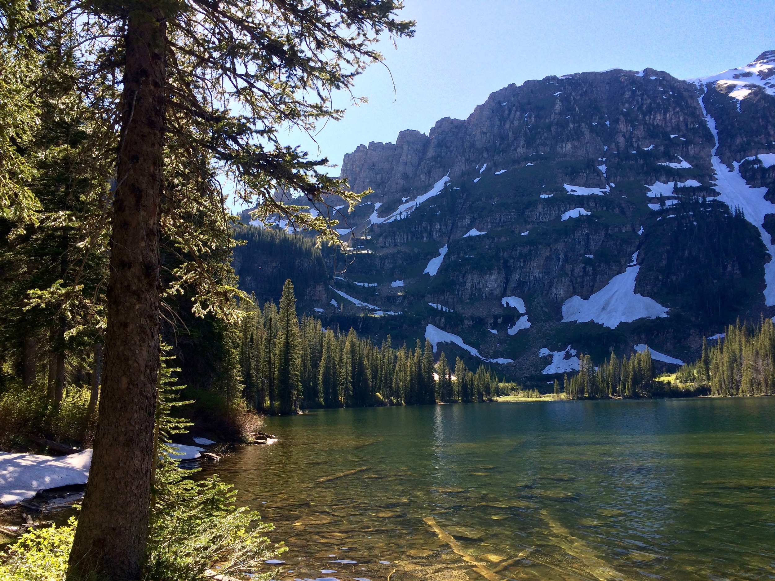
I detoured around the breeding pit and found a campsite on higher ground above the southern shore.  Summit Lake held a dramatic position beneath Eagle Pass and the towering face of Mount Calowahcan.  Submerged shelves of rock were scattered throughout the shallows, and from a distance they looked like the remnants of an Atlantean city.

A logjam blocked the outlet of the lake, and dozens of trout lurked within the labyrinth of tree trunks, waiting to ambush anything tasty that might try to exit the pond.  As I balanced on a log and dunked a washcloth in the moving water, I wished I’d brought a fishing pole with me.  Then again, I’d seen a pole snapped in half along the trail, and with all the overgrowth and deadfall, I doubt that mine would have survived the journey.

A blob of grey fur with a rat-like tail dashed onto the logjam bridge while I was washing up.  I think we noticed each other at the same time, but the meadow vole was quite shocked by my presence.  It immediately slipped on a log, crashed full speed into the water and disappeared.  I wondered where it had gone… perhaps snatched up by a hungry trout.  Surprisingly, the rodent managed to swim the remaining distance under the logjam.  It sprung from the water on the other side of the outlet and, without bothering to shake itself off, sprinted to the safety of a pile of boulders.

I lit a fire that evening, just in case the mosquitoes decided to speed up the hatching process for my sake.  They didn’t, but I was woken up twice during the night by other voracious animals.  Some rodent – perhaps that very same meadow vole - tried to chew its way into my tent to sample my trail food.  I finally wised up and triple-bagged my snacks so the smell wouldn’t be so attractive.  Should’ve been following that policy anyway, camping in grizzly country.

In the morning, I climbed Eagle Pass and scaled Calowahcan’s south summit to get a good view of the rest of the Mission Range.  Somewhere to the west on the Flathead Reservation lay a 120-year-old church and the remnants of the Catholic mission that gave these mountains their name.  My own mission, so to speak, was nearly complete.  I dropped 5,500 feet in the next four hours, my downward momentum helping me plow through the dense vegetation.  Despite losing the overgrown trail several times, I managed to regain my bearings and bushwhack across to Lake McDonald to reunite with my jeep once more.

In my absence, the vehicle had been invaded… by mice.  The little vermin had nibbled away at a cache of granola bars and peaches, leaving behind a dismaying number of fecal droppings.  They’d even taken a napkin and begun to build a shredded nest beneath the back seat.  I should have known better than to leave food at a trailhead, too.  As I always suspected, it’s the littlest creatures – not the thousand-pound giants - that you really have to keep an eye on.

Week Four: Feel the Burn

WEEK FOUR: FEEL THE BURN

As fires continued their sweep through the Santa Ynez Range of Southern California, one thousand miles to the northeast I was busy exploring my own piece of singed territory.  In 2003, the Hidden Lake Fire scorched the slopes of Montana’s Pioneer Mountains, burning thousands of wilderness acres, including the route to Sawtooth Lake that had captured my current interest.  On a June afternoon in 2016, the forest along the trail was a mix of the living and the dead.  A few survivors stood tall, but scattered across the forest floor lay the fallen soldiers of the incendiary war.  The next generation of lodgepole pines had taken root in the graveyard, promising a return to shadier times in the distant future.

In the back of my mind, I was slightly worried about what the media in California was calling the Scherpa Fire.  Sparks from a wood splitter had ignited the 8,000-acre blaze, which now smoldered less than four miles from the red cabin I called home.  My girlfriend Kitty was prepared to rescue any material goods from the cabin if necessary, so I tried to relax and focus on the task at hand.

Hiking to Sawtooth Lake was simple.  I could clamber over most fallen trees, and a few had even collided above the trail to create archways that I could pass through without ducking.  But upon reaching the lakeshore, I was able to choose among destinations with more adventurous potential.  Two mountains cast their reflections in the subalpine waters.  Sawtooth Mountain had a broken and toothy ridgeline.  If I tried climbing along that blade, I’d likely get slashed, if not outright sawed in half.  I felt drawn instead to Highboy Mountain – Sawtooth’s slightly higher and more approachable brother.

To reach Highboy’s upper slopes, I had to chart my own course through a lodgepole forest that had been untouched by the Hidden Lake Fire – for which I was extremely grateful.  Bushwhacking through fire-burned lodgepole pine is the worst.  The charred trunks slowly topple over the course of decades, creating dense thickets of spindly material that are guaranteed to trip up the most light-footed hiker. 

In contrast, bushwhacking through fire-burned chaparral in Southern California is the best.  The Mediterranean climate there supports a dense, drought-resistant plant community of shrubs and grasses, and fighting one’s way through it is an exercise in self-punishment.  There’s no winning strategy; the best one can do is use brute strength to crash through the brush and suffer the scratches and lacerations as well as one can.  After a conflagration like the Scherpa Fire, however, everything is reduced to bare soil and grey ash.  A person can hike anywhere, and the unrestricted mobility is a revelation.  I looked forward to seeing if any new opportunities for exploration had opened up when I returned in the fall.

Where the forest ended, the stairway up to the Highboy ridgeline began.  I didn’t mind the steepness, so long as I found room to avoid the snowbanks and unanchored boulders that the mountain laid in my path.  In short order, I breached the gauntlet and rested atop the mountain crest, content in my victory. 

Around me grew the makings of a stunted garden – scattered bits of alpine vegetation that nestled in the scraps of soil between the stones.  The plants scarcely dared to poke their heads out above the rocks, for the wind at 10,431 feet was fierce and cold.  They seemed to use their flowers like a blanket, growing them in tight layers of baby blue, yellow and magenta to help shelter their tiny leaves.  As attractive as the flowers were, I wasn’t surprised to find a lack of butterflies at this elevation, even with the temptation of deliciously cooled nectar.  Their wings were too fragile.  The task of pollination fell instead to the flies, who were less likely to be torn apart by the gusts that frequently swept Highboy’s summit.

A solitary pika, shaped like a lumpy potato with little ears and whiskers, played hide-and-seek with me in the talus for a while.  Eventually it decided that I posed no threat, and it made the unusually brave move of bounding to a nearby patch of grass and nibbling some blades in plain sight.

I chewed on some granola bars myself and surveyed the scenery, which included a dozen mountain ranges, some extending all the way into Wyoming and Idaho.  Ice floes were still breaking apart on the lakes beneath Highboy.  To the east, multiple grey scars discolored the foothills of the Pioneers where the Hidden Lake Fire swept through over a decade earlier.

The regeneration strategy of lodgepole pine forests depends on specialized pinecones sealed with resin that open to release their seeds after being exposed to extreme heat.  Lodgepole pine bark is rather thin, so this is the only way the species can endure a severe forest fire. 

Back in California, the shrubs along the devastated hillsides use different tactics to ensure survival.  Scrub oak and manzanita invest energy and nutrients in creating “root crowns” that grow fresh shoots whenever the vegetation above ground is completely incinerated.  Other plants like ceanothus form thick coats around their seeds that only crack at high temperatures, allowing water to enter so the dormant seeds can germinate.

I had no concerns about the chaparral landscape of Southern California being able to restore itself.  My cabin was a different story, however.  I’d have to keep my fingers crossed and hope the firefighters could spread enough retardant along the ridgeline that separated my home from the Scherpa Fire.  Much of the foliage there contained highly-flammable natural oils, so if the wind picked up, suppressing the flames wouldn’t be easy.

I took a short cut off of Highboy Mountain, glissading a thousand feet down a network of steep snowfields.  My sneakers served as rudimentary skis, and whenever the snow became too soft to keep me from falling through the crust, I simply dropped onto my backside and began sledding.  Hands and hiking poles helped to control my descent, but once I noticed I couldn’t feel or move my fingers anymore, I decided the merriment had to come to an end.

I traversed over to some rocks and tore off my soaked, threadbare pair of cotton gloves.  As circulation returned to my frostbitten hands, they burned, as if every nerve ending had been lit on fire.  But the flames eventually subsided, just as they would, sooner or later, in California.  I flexed my fingers to keep the blood moving, and continued down the mountain.

Week Three: The Boiling Point

WEEK THREE: THE BOILING POINT

The confrontation was inevitable. 

Throughout the Rockies, snowmelt had been trickling down into meadows and marshes for weeks, creating the perfect breeding ground for mosquito larvae.  Now the larvae were old enough to hatch into their winged forms and start venturing forth from the waters in search of their first meals.  For males, that meant nectar from flowers.  For females, that meant people like me who dared to think they could walk into the wilderness without attracting the insects’ bloodthirsty attentions.  I should have known better.  In the month of June, the mosquitoes always win.

Granted, in Yellowstone National Park I should have had a lot of other competition as a blood donor, what with all the bison, wolves, elk and grizzles wandering about.  There were very few humans, however… none in fact, after I hiked three miles down the trail towards Shoshone Lake.  Back at the ranger station, I had wondered why I’d managed to acquire camping permits on such short notice, especially for a popular lakeside campsite in a park that gets over four million visitors a year.  The lake even had its own geyser basin containing one of the highest geyser concentrations in the world. 

Halfway down the trail, I began to understand why I’d such good luck with permits.  For one, the mosquitoes were atrocious, and my “natural ingredient” bug spray only seemed to tickle their antennae for a few minutes before they regained their composure and renewed their attacks.  Secondly, the trail was still encumbered by snowdrifts - guests from the long Wyoming winter who had overstayed their welcome.  The snowy barriers gave Shoshone Lake a feeling of great remoteness, even if it lay only nine miles from the trailhead.

I found my campsite, pitched my tent in the trees and fled down to the lake where the mosquitoes weren’t quite so persistent.  After wading out into the shallows and washing off multiple layers of bug spray, I decided to relocate my tent to a gravelly terrace by the shore.  But the meager wind died, and the mosquitoes found me there, too.  I had to start up dinner on my camp stove and flee to the safety of the tent.

The transparent mesh of the tent fabric provided only a dim view of my surroundings, so the soundscape of Shoshone Lake became the focus of my senses.  There was the drone of hovering mosquitoes as they probed tirelessly for weaknesses in the tent lining.  Elsewhere, a beaver made sneezing sounds, clearing its nose while it paddled across the lake.  The noise from a bubbling hot spring cauldron drifted across the bay, remarkably similar in nature to the rice simmering in my cookpot.  And the honking of geese echoed fourfold as it bounced from lakeshore to lakeshore, occasionally rising to a cacophony as the birds struggled against their squabbling natures to get along.

The next morning, I decided that despite my two-night permit, I didn’t really need an extra day at Shoshone after all, even if it was the largest lake in the lower 48 states inaccessible by road.  The mosquitoes had convinced me that I’d seen enough.  I packed my gear and made a beeline for the Shoshone Geyser Basin, which lay behind a hill on the western shore.

To have a geyser basin all to oneself at Yellowstone National Park was like stepping back in time.  No crowds, no boardwalks, no guardrails, no informational pamphlets… this was a chance to study bubbling hot pools and geysers closer than ever before.  I still had to be extremely careful to stay on the crumbly, white sinter, and not just for my own sake.  I didn’t wish to disturb the rust-colored ribbons of bacteria that flourished in the thin sheets of water that ran from the hot springs down to Shoshone Creek.

I stepped lightly as possible around the turquoise pools and steaming fumaroles, knowing that a man had been boiled alive here in 1988 after falling into one of the hydrothermal features.  In some places, the ground simply hissed at me, though I could detect no heat or steam arising.  I still felt the same tension as being around an angry rattlesnake.

Other elements of the basin were more visually dramatic, none so much as Minute Man Geyser, which unleashed a twenty-foot jet of superheated steam every sixty seconds, more or less.  It certainly stole attention away from the other pools on the hillsides, though Union Geyser had a louder plumbing system.  The ground around Union vibrated ominously with a low-frequency rumble, like the sound of a distant jet plane. 

It was hard to fathom what could be transpiring in underground passages beneath the spring, but geologists have a pretty solid theory that starts with water percolating down towards Yellowstone’s great magma chamber, five miles below the surface.  The immense pressure at those depths keeps the superheated water from boiling, though periodically the water will rise and start to depressurize, forming bubbles of steam.  These expanding bubbles fight to escape upwards through constrictions in the passages, surging so violently that the water above them is ejected from the earth.  The internal pressure then decreases and the clock is reset until the next geyser eruption.

As safe as I tried to be around the fragile crusts, I was forced to take some unexpected risks when I encountered a strange species of bee in the basin.  These insects with black bodies, yellow legs and green eyes were swarming in great numbers across patches of grass, holding low flight patterns and circling around each other at great speeds.  They had perforated the ground, including parts of the footpath, with small holes, which they occasionally entered for unknown purposes.  Not knowing what behavior would set them against me, I had to detour from safer terrain into the danger zone, closer to the geysers than would be normally prudent. 

As the sulfuric mists washed over me, I noticed one side effect: no mosquitoes!  In fact, I’d scarcely been bothered since I entered the geyser basin.  Sulfur must be the bloodsuckers’ kryptonite.  If someone put that stuff in an aerosol can, I’d bet they could make a fortune. 

I let the vapors infuse my clothes before departing the region and decided that if it weren’t illegal, I’d camp right next to Minute Man Geyser next time, bees or no bees.  My food might taste faintly like poisonous chemicals, but at least I’d be able to eat in peace.

Week Two: The Bear Went Over the Mountain

WEEK TWO: THE BEAR WENT OVER THE MOUNTAIN

The grizzly tore down the sagebrush hillside – a rippling mass of fur and muscle that seemed hell-bent on covering as much ground as possible.  It reminded me of an escaped convict, as I could think of no other reason why something so fierce and formidable would be fleeing so recklessly.  I urged my jeep Charlie forward, hoping I could intersect with the grizzly when it crossed the road ahead, but ruts and potholes hindered my plans.  The beast got to the road while I was still a hundred feet away.  It stood up on its hind legs for just a moment to assess the interloper, then dropped down an embankment and out of sight.

I parked where the bear had disappeared, grabbed my camera and ran to the edge of the embankment.  No sign of the humpbacked creature.  It didn’t seem possible that it could have reached the edge of the forest below in time, and that realization made me suddenly nervous.  I spun my head towards every bush in the vicinity, making sure there were no bears lurking about.  After witnessing their speed from afar, I had no desire to see a close-up demonstration.

Wildlife had been tremendously abundant in this part of the Absaroka Range, east of Yellowstone National Park.  Herds of elk, deer, pronghorn and yes, cows – this was Wyoming cattle country, after all – roamed across the rolling grasslands, which were bordered by white-capped mountains on almost every side.  I felt bad for Charlie, who had to deal with rocky roads and numerous stream crossings as we pressed onward towards one of those peaks – the 12,319-foot monstrosity known as Carter Mountain.

We were both sufficiently rattled by the time I called a halt and agreed to travel the rest of the way on foot.  While I was packing my bag, a loud whuffing sound made me turn towards the trail, in time to see another grizzly exit the woods.  This one seemed to be grunting and breathing heavily with every move.  It also didn’t like the looks of my jeep and I, and it scampered up the opposite hillside, wheezing all the way.  I guess I’d be asthmatic too if I had to carry all that weight around with me. 

That made two bears.  As I set off down the trail, I had a weird feeling that the third one was going to be a doozy.  Many people recommend using bear spray to defend themselves in these situations, but the only animal I’ve managed to take out of commission with the stuff is myself.  I once had a can of spray holstered on my hip belt, and when I was making a leap onto a trail, my hand struck the trigger and caused a jet of concentrated pepper to shoot straight up my nostrils.  I had to spend half an hour with my head beneath a waterfall, rinsing out my nasal passages before I was able to think straight again.

Piles of shredded white fur lay to the sides of the trail, however, making me very conscious of being a vulnerable, minority species out here.  And when I left treeline and began wading through the dry tufts of last year’s alpine grasses, I was astounded to see how many bones littered the hillsides.  Leg bones, jawbones, vertebrae… far more numerous than I can recall finding anywhere in the wilderness.  Strangely, there was no sign of the living.  Green grasses were only just beginning to sprout from the mountain slopes, so perhaps the terrain was not yet attractive to the hooved grazers.

But besides bears and bones, I had other issues to contend with.  Mainly navigational.  I had come to Carter Mountain on a whim after seeing its giant profile from a rural highway.  Carter was not just a mountain, but a massif - a colossal mass of rock thirty miles long with thirteen unnamed summits, none of which stood out among its neighbors.  It was the largest mountain in the Greater Yellowstone Ecosystem, and successfully climbing it meant finding the one summit that rose a few feet higher than the other twelve.  That would prove challenging.

The maps and vague directions I gleaned off the internet weren’t very useful.  I couldn’t tell if I was approaching Carter Mountain by way of the right valley.  From so far below, it was impossible to gauge the relative height of Carter’s summits, especially when the differences in elevation were so minor.  I had to pick a summit that might be the highpoint of Carter and hope for the best.

I hiked up to the sheer face of the mountain’s upper slopes, then scaled a side ridge that promised an easier route to the summit.  Unfortunately, a series of breccia towers crowded the ridgetop, complicating the final distance.  I skirted some and scrambled up the others.  The towers appeared to be constructed from layers of balloon-sized, rounded cobblestones, each of which seemed likely to come loose beneath my fingertips.  Patches of gaudy orange lichen clung to every surface, however, and their flamboyant presence served to lighten the precarious mood.  I felt somewhat reassured; if the mountain wanted to kill me, I didn’t think it would be so cheerful about it.

Beyond the towers lay a rounded summit cloaked in a thick blanket of snow.  I reached the high point with little fanfare, then continued just a bit further, fighting the intense wind so I could peer down the western slopes.  The mountain fell away steeply, breaking apart into a series of towers and spires until it reached the shore of the Shoshone River, six thousand feet below.  Beyond lay more snowcapped ridgelines as the Absarokas stretched into the eastern reaches of Yellowstone Park.

My triumph felt incomplete, though, because several summits to the south looked higher than my present position.  I must’ve followed the wrong creek into the wrong valley.  Bad luck.  But since there was still time in the day, I trudged along the snowy backside of Carter Mountain until I reached the next high point. 

I feared I could go no further.  The true summit lay some distance away, separated by a short, but dangerous stretch of steep snowbanks and knife-edged fins of rock.  Without crampons or an ice axe, there was too great a likelihood I would slip and slide out of control, tumbling through the towers and ricocheting down to the valley floor.  There was nothing to be done about it, so I continued a short ways further in order to find a slope I could use to return to lower elevations.

I don’t know what caused me to reconsider.  I was all set to return to the trailhead, but something inside me managed to tip the scales away from common sense towards foolhardy adventure… though only just barely.  I found I couldn’t stop staring at a solitary line of elk tracks that traversed the entire length of the dangerous ridgeline.  The feat looked impossible; at the least, I couldn’t fathom why any creature would do such a thing.  I needed to see for myself.

Soon I discovered that the snow slopes, though steep, were thoroughly wet and soft.  Even if I slipped, there was a good chance I could claw my way to a stop before I built up too much speed.  During the more vertical sections, I diligently kicked steps into the snow with my boots so I could center my gravity and not fall backwards.  The animal I’d been following appeared to have done the same, for the tracks went deep, and - wait a second… those are bear tracks!

What I’d thought were the prints left by an elk’s hooves now showed the unmistakable indentations of five claw marks in front of a rounded pad.  Here was my third grizzly, and wouldn’t you know it… the beast was just as much an adventurer as I was.  I couldn’t fathom why the creature felt it needed to haul its bulk up and over one of the trickiest routes on the mountain when any number of alternatives – such as going around the massif – would have been easier.  Whatever its reason, I was grateful for the company.  And jealous that bear claws work like natural crampons.

To compensate for my lack of claws, I moved to the exposed rock of the cliffs where the melting snow had revealed some handholds and footholds.  Eventually, the ridge came to its narrowest point, dropping steeply away on both sides so that any slip would trigger a long tumble towards disaster.  In addition, a layer of snow disguised the rock features so I couldn’t tell where solid ground existed or where the boulders were likely to break loose.  I had to hunch over and grasp the ridge with all four limbs, essentially giving the mountain a bear hug and making slow, careful adjustments to my weight as I inched my way forward.  Panic fought to disrupt my concentration, but the tracks of the grizzly provided silent encouragement.  And when the ridge widened, I stood up on two legs and approached the summit as a human once more.

From there, the highest point on Carter Mountain was just an easy jaunt across a half-mile of snow.  The wind at 12,319 feet was absolutely ferocious, however.  I huddled behind a battered weather station, ate a victory snack and peeked out to snatch occasional views of a mountain range still struggling to free itself from the grip of winter.

The bitter wind encouraged me to move along, so I dropped down the east side of Carter and enjoyed a soft descent through a snowy basin to reach the left fork of Pickett Creek.  A few hours later, I arrived back at Charlie and was relieved to see that Bear Number Two hadn’t broken through a window and ravaged my food supplies while I was away.  The bears of the Absarokas had been good to me.  Wherever they had gone, I wished them all full bellies, warm nights and safe passage to whichever parts of the Rockies their big paws might take them.

Week One: Out of the Frying Pan and into the Freezebox

WEEK ONE: OUT OF THE FRYING PAN AND INTO THE FREEZEBOX

I rolled over in my sleeping bag, causing a mass of snow to slide down the side of the tent and hit the ground with a thud. Not a sound that boded well for my outdoor ambitions. It was tempting to linger within the realm of warmer dreams, but I made myself crawl out of the tent and kick through the snowdrifts along its perimeter so that I could assess the situation.

My Colorado campsite had become a winter wonderland. Over two inches of snow blanketed my jeep and the surrounding forest - quite a change of scenery from the sweltering edge of the Grand Canyon that I’d visited two days earlier. Summer travels this year had begun with tumbleweeds, jackrabbits and dusty desert roads. Now I faced freezing temperatures and an extra challenge in climbing 14,014-foot San Luis Peak. Two inches isn’t a lot of snow, but I suspected I still might be, as the saying goes, in over my head.

First, I went out to stare at the road. I’d driven up several miles of steep gravel and dirt to reach 11,000 feet, and I feared that if I tried to take my jeep – nicknamed Charlie – down those slopes while they were covered in powdery snow, he could very likely slip, lose traction and plummet into West Willow Creek Gorge. Charlie had just celebrated his 350,000th mile a few days ago, but my carelessness with the weather may have caused this to be his last trip into the mountains – ever. All the grandiose goals for my final summer writing for the Evening Sun newspaper, including plans to climb the highest mountains in Montana, Nevada and Wyoming, might get derailed in my very first week of travel.

Rather than gamble on the roads, I decided to pack a bag and start hiking in the opposite direction, up the snowy, eight-mile trail to San Luis Peak. The mountain was possibly the easiest of the fifty-four Colorado Fourteeners in that all its slopes were reasonably gentle. I’d have to search pretty hard in order to find a cliff to fall from.

Unfortunately, the fresh snow made every footfall a little more tiring, and I'd handicapped myself severely by giving myself no time to acclimatize to the altitude. A little exercise at high elevations can trigger one’s body to produce more red blood cells, which helps a person transport oxygen more efficiently. At 14,000 feet the air is much thinner, with only about half the available oxygen that exists at sea level. I increased my breathing and heart rate to compensate and tried to convince my red blood cells to work overtime, but they certainly weren’t happy about it. A 12,000-foot peak would have been much more reasonable, or even a 13,000-footer. If blood cells had unions, I’m sure mine would be striking over working conditions.

Still, the scenery buoyed my spirits enough for me to keep putting one foot in front of the other. Above me, the contours of the upper mountains were smoothed over by a thick blanket of snow laid down by multiple storms. Aspen trees slept contentedly in the valleys, having made the wise decision to delay growing new leaves until they knew winter had departed for good. The few pine trees to venture past treeline were stunted and encrusted with frost; their recovery would be even more heroic. San Luis Peak kept its face in the clouds, and I could only hope the mists would lift by the time I got there. As it was, I almost made the decision to turn around a dozen times during my approach. I knew I could reach the top… I just wasn’t sure if I’d have enough energy to get back to the trailhead.

A lone coyote bounded down the hillside and came to a skittering stop right in front of me, spraying powder in all directions. A large rabbit hung limply in his jaws. Before I could lift my camera, the canine made a quick decision and bounded up another hill, leaving paw prints in the snow and drag marks from the dangling legs of his prey. Considering the season, I suspected the meal was reserved for the coyote’s pregnant mate or a litter of hungry pups.

Ultimately, I too was successful at reaching my quarry. The snow stopped swirling about the peaks long enough for me to attain San Luis’ summit and catch a glimpse of the rest of southern Colorado. I’m not much of a winter hiker, so the view felt like a behind-the-scenes look at a region preparing for a much more colorful grand debut. Rehearsals for these mountains were performed in monochromatic costumes - all white ridgelines and black, forested valleys. I wish I could have seen the place fully exposed in summer, but the wintry perspective was a rare treat.

On the descent, I quickly realized that my lack of acclimatization was going to be a problem. The scarcity of oxygen began to cause blood vessels to swell in my brain, bringing on a bad migraine headache, and ibuprofen wasn’t helping ease the symptoms any longer. If I could drop elevation quickly, I would recover from the altitude sickness. But my route traced the upper edges of two alpine basins, keeping me above 12,000 feet for many miles. I had hoped that the return journey would be easier because I had already cut a path through the snow, but high wind and intermittent squalls had filled most of my footsteps with fresh flurries, forcing me to wade through the drifts once again.

Then the sun became my enemy. Ultraviolet light cut through the thinner air and struck me from above and below, reflecting off the crystalline snowfields. The rays easily penetrated my cheap pair of dollar store sunglasses and worsened my headache. I felt my vision was beginning to dim, and I suspected the onset of snow blindness. Truly I had not prepared well for the season.

The sunlight warmed the surface of the snowbanks as well, so that my feet frequently broke through the melted layers and didn’t stop plunging until I was waist-deep and nearly immobilized. I grew exhausted from having to constantly extricate my legs so I could rise back to my feet. I hadn’t budgeted enough energy for this, nor did I have enough oxygen to keep my muscles working properly. Nausea and hypoxia began to affect my balance as well. I started drunkenly stumbling about the time I reached an avalanche zone, and when I looked up and noticed the volume of snow collected on the slopes above me, I realized that I needed to find some reserves of willpower fast so I could get myself out of there.

Somehow I managed to haul my body out of the alpine basin and onto the final slope leading to the trailhead. I wished that I could have walked slowly so that the pounding of my feet wouldn’t exacerbate the pounding of my brain, but one last worry was creeping into my feverish mind. Since the sun hung lower in the sky and the temperature was dropping quickly, I feared that the snow on the roads might be starting to refreeze after softening all afternoon. Charlie and I might be forced to drive down a surface even more slippery and icy than it was this morning.

I really need a miracle, I thought to myself as I pushed my tired legs down the hill. Charlie’s life might be at stake. If I played it safe and waited for the fresh snow to melt completely, I might not reach Denver in time for my friend’s wedding, and that was why I’d traveled to Colorado so early in the season in the first place.

At last I came to the trailhead… and discovered my miracle. Not a speck of snow remained on the road back to town. I couldn’t believe it, considering the chilly temperatures. I could only speculate that the dry air of the Rockies caused the fresh powder to sublimate – a phenomenon where ice converts directly into vapor without going through a liquid state first.

However it happened, I was relieved beyond measure. Charlie could now descend safely, I’d be able to shake my altitude sickness, and my attendance at the wedding was assured. One troubling thought remained: if I was already getting into this much trouble after only four days of travel, then after a full season of outdoor adventure writing I was going to either end up like that coyote or like that rabbit.

May my canine instincts serve me better in the weeks to come.

Interview #3: G.O. Get Outside Podcast

This was recorded several months ago, but I timed my new book to coincide with the podcast’s release. The interview was superbly edited, so I highly encourage you have a listen! Find on iTunes or click here:

http://www.gogetoutside.com/g-o-028-bryan-snyder/

G.O. Get Outside Podcast Episode 028 – Misadventures Off the Map With Bryan Snyder

Self-proclaimed renegade car camper Bryan Snyder has a penchant for finding trouble. Each summer, he travels across the U.S. with his trusty sidekick, Charlie—his aging Jeep. He shares his misadventures with heights, weather, wildlife, and circumstance through his books and ongoing column in the Chenango County newspaper. One morning he and Jason huddled amongst some boulders at the Santa Barbara Museum of Natural History and discussed Bryan’s numerous adventures, his path to self-publishing, the merits of Outdoor Science Schools, and the allure of off-limits European towers.

RELEASE DAY!

BOOK RELEASE DAY!

Let me introduce Renegade Car Camping: A Guide to Free Campsites and the Ultimate Road Trip Experience.  Sometimes in life, you get the chance to teach about what you’re uniquely qualified to teach.  This is MY compiled wisdom, such as it is, from all those years traveling cross-country and trying not to go broke.  If you’ve read about WHAT my Jeep Charlie and I do every summer… this is HOW we do it.

Find it on Amazon for 99 cents: http://www.amazon.com/dp/B01EZ8VP7Y

Alternatively, you sign up for my mailing list at: www.offthemapbooks.com/freebook and get a FREE copy of Renegade Car Camping. 

The mailing list should be fun, regardless if you download the book that way.  You’ll get new stories over the summer while I’m traveling, plus additional content. 

I hope you enjoy the book.  And please share these links with anyone you think could benefit from a good, long cross-country trip.  Thanks!

Interview #2: The Funkzone Podcast with Ted Mills

A couple weeks ago, I sat down on my back porch with writer/director Ted Mills and talked about travel, festivals, inspiration and our local Santa Barbara backcountry.  Two weeks later, we sat down AGAIN because of recording glitches, but it was such pleasant company that I didn't mind.

https://itunes.apple.com/us/podcast/funkzone-podcast/id952182542
http://www.stitcher.com/podcast/the-funkzone-podcast-with-ted-mills
http://www.funkzonepodcast.com/2016/04/19/episode-071-bryan-snyder/

Subscribe to his podcast, which focuses on interviews with creative-types, and you'll also get a bonus reading of one of my book chapters.

Interview #1: Adventure Sports Podcast

I was interviewed on Travis Parsons' Adventure Sports Podcast last week about the "Off The Map" book series, and the episode (#135) was just released.  Tune in if you'd like to hear a whole lot of crazy stories scattered across several decades of adventuring.  And if you'd like to meet a whole bunch of other extreme outdoorspeople on a weekly basis, subscribe to his podcast!


Here are the links:
Direct Link: http://traffic.libsyn.com/adventuresportspodcast/Bryan_Snyder_Day_Hiking_the_American.mp3
Stitcher: http://www.stitcher.com/s?fid=61969&refid=stpr
iTunes: https://itunes.apple.com/us/podcast/adventure-sports-podcast/id972403908
Adventure Sports Podcast site: http://www.adventuresportspodcast.com

Off The Map Side-Stories #4: Riders of the Storm

Off The Map Side-Stories #4: Riders of the Storm

IMG_2349.jpg

A powerful storm was expected to slam into Southern California during the weekend of the Laurel Mountain horse endurance race, so the ride managers graciously allowed Kitty and I to stay in the guest bedroom of their home, seven miles from the starting line.  All the other race participants had brought RVs or fancy horse trailers that held human living quarters.  Kitty and I had only a teepee to sleep in, and I think the managers, Dave and Annie, worried about the extreme wind advisory that was in effect.  They didn’t want our teepee to uproot itself and go crashing through horse camp, scaring the animals and causing a stampede.  After arriving at the site in the Mojave Desert and getting battered about by the first gusts of the storm, I conceded the managers were probably wise to extend their hospitality.

In exchange, I volunteered to work the race while Kitty rode her black Tennessee Walker named Merlin.  I set out buckets of water and helped make sandwiches for the wind-battered riders.  When they came in out of the Mojave Desert for their lunch break, I recorded their names and times and I told them when the enforced hour-long rest period was over.  The fierce wind was unrelenting, and my baseball cap would not stay on my head longer than ten minutes.  After my cap finally blew into a horse bucket, I gave up and let my hair blow in any direction it wanted to.

Endurance races are usually calm affairs.  Most people on the 25 or 50-mile rides are there to enjoy the scenery and the experience.  There are awards given for best time, but veterinarians will disqualify a horse if they are ridden too hard.  Awards for “best condition” are also given to help encourage riders to not push their steeds too far.

Despite being bullied about by the wind and having their helmets blown sideways, none of the forty riders fell off their horses during the race.  The last rider walked her horse into camp during sunset, which was an absolutely stunning spectacle due to the stormclouds brewing over the southern Sierras. 

The next morning, we made one last hurried dash back to horse camp to retrieve the remaining infrastructure, while the rising sun cast a rainbow into the dark clouds to the west.  If we’d had more time, Kitty and I would have gone with the race managers to help out a neighbor who’d called in a panic that morning, claiming that the wind was literally blowing the roof off his house.  Gusts of up to 75 miles per hour were still in the forecast that afternoon.  But we had to take Merlin home so we could report to our jobs the next day.

Kitty did exceptionally well driving her horse trailer in the heavy wind and rain.  The storm even threw rocks down upon us when we drove through the mountain passes.  Ten miles from home, we thought we had braved the worst.  But then an unexpected gust struck the trailer from behind, whipping past Merlin’s head and exploding a window from the inside out.  We couldn’t believe it.  As for the panicked Tennessee Walker, he had had enough of travel and was ready to get back to grazing on the fresh grasses in the meadows around his corral.  Kitty and I were more than ready to put four walls between ourselves and the wind.  We looked forward to a calm evening, where the only race we had scheduled was a race to see who would be first in bed.

Off The Map Side-Stories #3: You Can’t Go Home Again

Off The Map Side-Stories #3: You Can’t Go Home Again

As Christmas approaches....

I'm riding a bus back from LAX airport and waxing melancholy.  Tonight is likely the last for Lora's greyhound Chuck.  He had a happy life, but one month ago Lora found a large cancerous mass on his liver and spleen.  Three days ago he was sprinting around like a maniac, as greyhounds do, but something must have ruptured for good.  Soon he will finally rest.  I'm meeting Lora at a doctor's house, where Chuck will spend his last moments surrounded by loved ones.  Yesterday, I visited my Grandma at the nursing home.... she turns 102 tomorrow, but she sleeps almost all the time now.  She will pass soon, surrounded by loved ones.  In this article that I wrote on the airplane from New York, I talk about saying goodbye to a favorite outdoor location from my youth that I will never be able to experience in the same way again.  It's a time of transition, and in those times, it's good to remember what you gained from knowing the things that leave you.  They don't leave you empty.... they leave you a changed person... changed for the better, one hopes.

IMG_2680.jpg

Off The Map Side-Stories #3: You Can’t Go Home Again

During a break in the rain, I wandered into the forests surrounding my old neighborhood in upstate New York.  The region had failed to create a white Christmas for its returning native sons and daughters, though it had tried to be resourceful.  The forest floor had carefully collected and preserved the scant wisps of snow that had fallen on a previous evening, cradling them within the curled ridges of oak, maple and beech leaves.  But unseasonable warmth had returned to the state, and even those small vestiges of wintry ambiance melted away.

Brown hues dominated the landscape, offset by the gentle greens of hemlock branches and the bright emerald shade of the lichen that coated several slabs of slate rock.  The slate outcroppings had always attracted me in my teenage years.  A circle of short cliffs ringed the highest hilltop, and a crisscrossing network of cracks made the leading edge of the cliffs vulnerable to fracturing and toppling over.  My friends and I called the most dramatic section Split Rocks, and the overhangs at the base of these cliffs formed small caves that sparked our imaginations.

Occasionally other elements sparked within these caves, such as the candles that tipped over during my brother’s occupation and caught the neighboring trees on fire.  He and his friends tried to urinate the fire into submission without success, and fire crews had to hike in with backpacks full of flame retardant to prevent a larger conflagration.  My brother and I built some fortresses from fallen trees during our younger years, but mostly I preferred to wander alone, mapping the extent of the slate formations with pencil and paper.  Days such as this one, when the leaves of the deciduous trees were bare and visibility across the forest was greatest, were always the best for mapmaking. 

The rainfall picked up again, and I took shelter beneath the hemlock stands.  Wildlife remained distant today.  Only chickadees chirped secretively to each other about the human in their midst.  The forest was no longer as quiet as I remembered, as the low rumble of combustion engines never faded into the background.  True wilderness could not be found in Upstate New York, sadly.  European colonists had laced the rolling landscape with roads, expanding pathways through every valley.  Even hilltops had been cleared, though on the highest hills the farming and grazing was marginal, so many forests had a chance to reestablish themselves.  When seeking solace and adventure as a teenager, I didn’t descend into the valleys; I climbed to the places that had been forgotten, where the relics left by previous settlers lay rusting amid the moss and blackberry brambles.

Despite knowing what I would find, I returned this morning to the foot of the Split Rocks and gazed grimly upwards at the mansion that now perched atop the most important hill of my childhood.  During my college years, developers bulldozed a wide swath along the crest of the hill right up to the edge of the slate cliffs.  Whenever I visited home, I would patrol the forest and rip down surveying ribbons, but my efforts did not keep the developers at bay for long, if at all.  Now there is a castle atop the hill, and I must prowl like a thief in a forest where I once ruled, scavenging for memories. 

Sadly, everyone wants their castle on a hill.  I know I do.  I actually grew up in a development not far away from here, and when that housing tract was built, undoubtedly it was loathed by some farmboy because it obliterated his favorite wooded playground.  It’s a tragic cycle.  Slowly, all the wide, open spaces get carved into pieces, and there becomes no way to escape the humming of combustion engines.  We build houses within the hilltop forests and destroy a little more of the places we love.  Until our species finds a way to stabilize its population, this outcome is virtually inevitable.

And yet, our destructive natures are balanced by the individuals and organizations that have advocated for setting aside public lands so that backyard spaces and wilderness areas will continue to exist.  Within my home county lie state forests.  I can drive a few hours to the northeast and southeast and reach the vast Catskill and Adirondack State Parks.  And of course, these open landscapes dwindle in comparison to the network of National Parks, Forests and Wildlife Refuges found throughout the American West. 

Public lands often find themselves under threat from irresponsible ranching, mining, logging, recreation and energy extraction interests, but they still represent hope… hope that humans are truly learning to curb their powerful appetites and will one day be able to balance their presence on Earth with the rest of God’s creatures.  Our stewardship of the planet is a vast experiment, with successes and setbacks.  I am optimistic that we can learn from our mistakes, and thrive, as a nation and as a community of species.  But today, I must mourn for the loss of my own forest.

I can no longer return to the hilltop above Split Rocks, except as an intruder.  At least I have my old maps to remind me of how things used to be, and the satisfaction of having explored every rock while I had the chance.  Now the chickadees will have to visit these places on my behalf.  The deer and raccoons can patrol the perimeter, and perhaps someday the descendants of these animals will reclaim the land, once humans find it in themselves to ease their grip and give some of the forests back.

Off The Map Side-Stories #2: Cache Flow Issues

Lee and I slid down the concrete wall into the channelized stream and turned to examine the tunnel.  It was tall and circular, so we wouldn’t need to hunch over like dwarves, at least.  A trickle of water slid lazily into the tube and disappeared into darkness.  Lee checked his smartphone one more time.  His geocaching app told us that the prize lay somewhere within this tunnel, underneath several roads and all four lanes of Highway 101.  The search was on.  I wish I’d brought a flashlight.

Geocaching is a new international sport that emerged in the era of global satellite positioning.  People began hiding containers in unlikely locations, posting the coordinates online to provide a sort of treasure hunt for weekend adventurers.  Whenever a container is located, the finder simply signs their name in the logbook and takes or leaves a trinket – some little coin, button or toy small enough to fit in the receptacle. 

This was my first introduction to the sport.  I walked carefully through the tunnel, using the indirect light of Lee’s smartphone to help me avoid the water pooling at the lowest points.  After a quarter mile, we still hadn’t discovered the cache.  The light at the opposite end of the tunnel illuminated the only dangerous section – a stretch of metal culvert that had partially rusted through, perhaps due to the pool of water three feet wide that had formed along the floor.  We had to straddle the pool with our legs stretched to their widest limit and waddle forward a few inches at a time in order to keep our boots dry.  I felt lucky that my thighs didn’t cramp.  If they had, I would have awkwardly tumbled sideways into a stagnant puddle… embarrassing for any adventurer.

We emerged at an intersection with an urban stream, full of refuse and the usual debris blown in from local streets and businesses.  On the other side of a second tunnel, the creek became channelized again, with eight-foot high embankments that were too slick to scale.  I wanted to get a look at the surrounding neighborhood, but to escape the creek I had to tap into some skateboarding moves.  I ran a step up one tapering wall, then back down and across to the opposite wall, running up that side and down again.  By banking from one side to the other, I built up momentum, increasing my height each time until I finally could latch my fingers onto the dirt above the wall and claw my way up.

That was fun.  But a neighbor with a barking dog warned us that a nearby property manager would call the cops on us.  We returned to the tunnel, and on our way back, I got lucky and discovered a camouflaged metal tin tucked into an alcove.  We signed the logbook and continued on. 

Other sites we visited that morning led us to funky and intriguing parts of town… places we would not otherwise have known existed.  I found one storm drain tunnel that I desperately wanted to squeeze into and explore, but that expedition will have to wait for another day.  For a person who normally likes to get away from the urban environment as much as possible, this was a great reminder that adventures can be found almost everywhere you look… and the geocaching smartphone tool can really get you looking in the right direction.


For more information on geocaching and to see more pictures, check back at www.facebook.com/offthemapbooks later in the week.

Off The Map Side-Stories #1: Double-Dipping

I aim to keep writing throughout the year... stories that I can dash off without too much editing... stories of adventure between the summer seasons. If you can think of a catchy title for this series, let me know! Here's the first:

Off The Map Side-Stories #1: Double-Dipping

Dolphins followed us to Santa Barbara Island, and dolphins followed us home, two days later.  In between, we paid for our ferry passage by getting our hands dirty, planting native seedlings to help restore a landscape devastated by a century of overgrazing by sheep, goats and rabbits.  It’s an economical way to see the island, and a satisfying experience to be part of the recovery process.

Santa Barbara is the smallest of the eight Channel Islands of the coast of Southern California.  The rainwater that soaks into the ground there isn’t sufficient to make streams or springs flow, so human habitation has never been a productive enterprise.  The National Park Service runs a campground, but you must bring all your own food and water supplies and hike them up a steep trail from the docks to the upper plateau.  Kitty and I were among the dozen volunteers contributing our time, planting coreopsis, silverleaf and cactus and feeding them precious water to tide them over until the rainy season.

On the second afternoon, we used our lunch break to hike down to the docks and investigate the potential for a midday swim.  Unfortunately, the waves at high tide were crashing violently against the rocks and wooden beams; we climbed down the metal ladder until we were waist-deep in the water, but we didn’t dare let go.  Around us, sea lions traced the shoreline and effortlessly spun their sleek bodies through the heavy surf.  We feared a rogue wave would smash us against the cliffs if we swam away and tried to return.  So instead, we played a vertical game of tag with the ocean, stepping to the lowest rung we had the nerve to reach, then clawing our way back up the ladder whenever a set of waves threatened to catch us and sweep us away.

Somehow, I kept my head dry until the final round of our game.  In truth, I thought the game was over, but as we were starting to climb to safety, one last wave ricocheted off the cliff beneath the dock and completely drenched me.  Sneaky ocean.  I needed to remember; the island may have appreciated our temporary presence, but the ocean owed us no favors.

Release Party Decompression

What an amazing night last night!  We had a packed gallery for Melanie Hutton's 11-person band, and I got to have a featured role on one of the songs... got to do my tinwhistle percussive flourishes, which I love.  I also served as the opening act for the concert, so to speak.... reading chapters from my book, sharing tangential stories and taking questions from the audience.  Many thanks for your participation and your laughter!  Also glad to have met many new people through the night.  It was a very smooth experience for me, and I'm greatly looking forward to (instead of dreading) future signings and readings!  I hope to share some portions of the night with you later in the week.  Until then, here's a picture from the considerate Boz Nobel:


RELEASE DAY!!!

A long last, my follow-up book, "Further Off The Map: Fifty-Three Tales of Adventure Along the Rougher Edges of American Wilderness" is finally available in paperback or Kindle editions on Amazon.com!  

http://www.amazon.com/dp/B017FC8MGO
http://www.amazon.com/dp/1514763389

To celebrate, I am throwing a release party tonight in Santa Barbara in collaboration with my friend Melanie Hutton, who is releasing her own CD of middle eastern/world music.  There will be stories and songs, with an 8-piece band!  And yes, I'll be playing my tinwhistle on a track or two.  Visit www.facebook.com/events/146904685661768/ to learn more about the event... perhaps to hear how it went!

I am immensely proud of the book.  The editing process was exhaustive, with several friends helping along the way.  These stories should give you many nights of entertainment, safe on your couch, in your bed or by your fireside.  And for the family members who might get freaked out at the cliffs, animals and violent weather, just remember.... I survived.  :)

Now, to congratulate you for getting to the end of this blog post, from November 12th-16th, my first book "Off The Map" is available to you on Kindle for FREE!  Find it here: http://www.amazon.com/dp/B00DAJR8U8

Enjoy the new adventures!

-- Bryan


Beginnings

Welcome to the new site, everyone!

This website has been in the works, at least in my mind, for a good while.  I wanted a convenient way for people to find me, and my writings, in a form that's less clunky than good ol' Facebook... although that page will continue to play host to fresh photographs in the years ahead.  Here, people can access...

GALLERY - A cascade of some of my best images over the years, for when you need visual inspiration

ABOUT - Where I can tell the story of how I came to be a reckless adventurer, and how I've survived.

JOURNAL - Where I can keep a bona fide blog... a home for summer articles and shorter pieces during the colder seasons.  Here I can also respond to questions from my readers and give advice about cross-country travel on a minuscule budget.

I hope you'll find something entertaining or illuminating within these digital pages in the months ahead.  Should you feel inspired, head over to the CONTACT section and let me know what you think!

Safe journeys,

-- Bryan