
Off The Map Side-Stories #13: The Escape Claws
“This is supposed to be a trail?”
The Meadow Creek Trailhead was well-marked, but it vanished into the forest after just a hundred feet. Because the Absaroka Mountains were notorious for grizzlies, I wasn’t in the mood to trounce around through the underbrush for too long. I had a peak to climb, and the blue skies that graced this forgotten corner of Wyoming weren’t going to last forever.
A forest-thinning project was likely the cause of the trail’s obscurement. I weaved around piles of trimmed branches and stumbled upon the trail by chance where it began to switchback up the side of the valley. Within a few hundred feet, however, I realized that my day’s ambitions might be on the far side of unattainable. My legs didn’t feel anywhere close to being up to the task. I’d spent the previous month working on my property in Montana, crouching for hours on end while I repaired the concrete curb and fence in front of my houses. Even though I’d done very little hiking, my legs looked buffer than ever because of all the squatting. But they were the wrong muscles. They didn’t translate to climbing mountains.
At 9,000 feet of elevation, my heart was pounding in my chest, and I had to take frequent breaks to stretch my legs and give them a motivational pep talk. At 9,500 feet, I finally found my stride. At 9,800 feet, I lost it again.
By 10,000 feet, I was ready to snuggle up to the nearest grizzly and call it a night. The exhaustion I felt was almost overwhelming. I would have sung or whistled to warn any neighboring bears of my approach, but I was too out of breath. At least I had bear spray with me. It would take all the remaining energy I possessed just to pull the trigger, I reckoned.
A heart attack-inducing explosion of sound jolted me from my stupor. Thankfully, it was just the launching of a grouse from the shrubs beside the trail. The noise shocked me back to full consciousness… not that I needed my blood pumping harder than it already was.
At last, I reached the welcoming vista of the Meadow Creek Basin - a grassy bowl with enough fir and whitebark pine trees to keep it interesting. It was a comforting sight except for the clouds developing above the headwall of the basin. Those innocent-looking tufts of moisture reminded me that I couldn’t indulge in any extended rest periods or else they’d merge into stormclouds and block my route to the summit.
So I kept each break to a minimum and trudged two thousand feet up the side of the valley. Clouds converged and darkened, leading me to believe I’d only be able to peek over the ridge before I’d have to descend to safety. But when I gained the ridgetop, I was relieved to see that the approaching clouds were fluffier than I’d been led to believe. I still had to cross three miles of windswept high-altitude plateau to reach my destination, Francs Peak – the highest point and the only summit above 13,000 feet in the Absaroka Range. If I dared cross this lofty, treeless expanse, there was a strong chance that storms would ambush me later in the day, during which time I would present quite an attractive target for lightning strikes. Afternoon thunderstorms were the norm in this part of the Rockies, and based on the rain that came down yesterday while I was car camping, I didn’t expect today to be any different.
Indeed, the clouds darkened again while I crossed the plateau. Depressions dotted the tundra where bears had dug out the roots of alpine plants for consumption - not any time recently, I hoped. I came to the end of the flat expanse where the Francs Peak ridge rose an additional thousand feet into the air, and I began to climb once more. Too late to turn back now. The telltale claw marks of a grizzly bear pressed deeply a patch of mud along my path, and that seemed recent enough for concern.
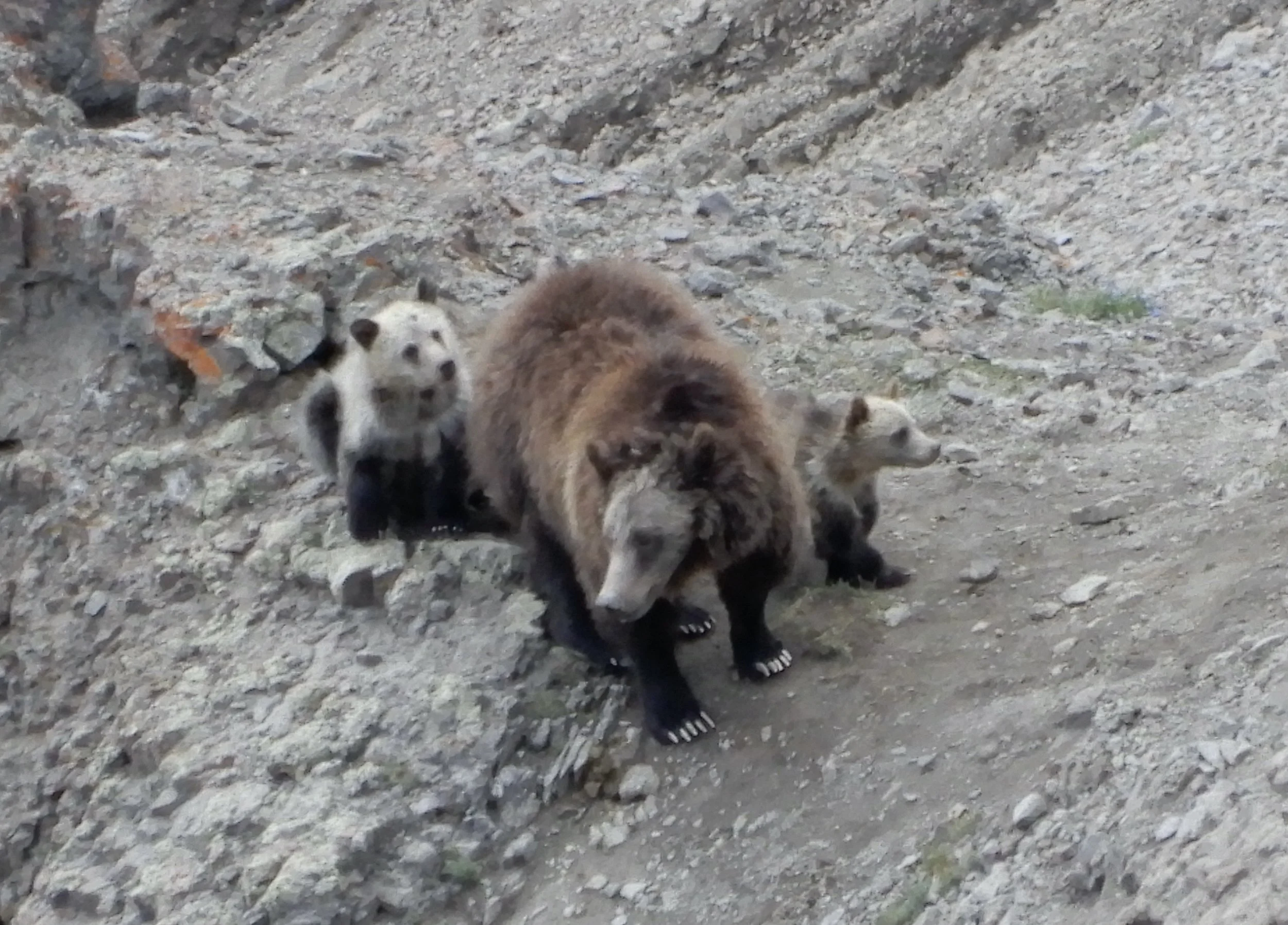
Not long afterward, I spied them – a mother grizzly and three black-furred cubs about a hundred feet up the trail. They eyed me with some alarm, and then the sow ushered her children down the side of the mountain. If they’d had summit ambitions, they were giving them up for another day.
As I neared the top, I glanced down on the rocky slopes below and noticed I was literally surrounded by bears. Some were individuals. Some were parents with cubs at their heels. Most of them rested amid the boulders, having filled their bellies with the moths and grubs they’d scavenged from beneath the rocks. The musky odor of their pelts wafted up the slope to my nostrils. I could only trust that they were fattened up and not interested in a heavier meal.
Thunder reverberated through the Absarokas and black clouds loomed in the west. It would be lunacy to attempt to summit, but I’d pushed my limbs to their limit and couldn’t conceive of turning around now. I hauled my tired body up the final distance, then took in the views wherever the dark cloud masses allowed. It was a tense couple of minutes, and when I felt a shock go through my right ankle, I jumped, thinking it was an electrically charged prelude to a lightning strike. But then the hail began to fall, which convinced me that the jolt had probably been caused by a speedy hailstone. Even so, it was time to clear out. I snapped some quick photos but didn’t bother to sign the logbook at the summit cairn… it wasn’t worth the risk.
Hurriedly, I descended two hundred feet until the meep of a squeaking pika drew my attention to the rocks on the side of the trail. The creature was well-camouflaged, but I spotted the hamster-sized, rabbit-like critter amid the boulders, whiskers twitching. Despite the storm and the close proximity of the bears on the slopes below, I paused, pulled out my telephoto camera and took pictures of the adorable little puffball for several minutes. Such is the power of the pika.
Enough time passed that the wave of stormclouds drifted away and sunlight struck the summit of Francs Peak. I was tempted to return and take a better set of photos. Indeed, I tried to climb the ridge again, but after a dozen steps, my legs refused to go any further. They rebelled, hijacked my brain and forced me to resume the descent.
It was for the best. More grizzly bears came into view below the ridgeline - nineteen in all, including the cubs, but thankfully none chose to challenge my claim to the high ground. I reached the plateau and began the three-mile crossing, hoping I might make it across the alpine terrain before the next wave of storms emerged. Unfortunately, heavy clouds descended, lashing me with rain and drumming my ears with bouts of tumultuous thunder. I couldn’t escape the danger by dropping down the side of the plateau early because I’d end up in an unfamiliar valley, leagues away from my car. So I was forced to gamble with the lightning and keep trudging across the tundra, getting wetter and colder. My heart was no longer pounding, but my brain had begun to throb from altitude sickness. This was the highest I’d hiked so far this summer, and my body wasn’t acclimatized as much as I would have liked. It was a miserable ordeal, and I couldn’t wait for it to end.
I decided I needed to take a shortcut into the Meadow Creek Basin for the sake of my bodily integrity. I’d seen a potential route on the way up – a steep ribbon of open hillside between two snowfields. To reach it, I’d have to pick a spot along the edge of the plateau and start descending, hoping I’d guessed correctly. If my instincts were wrong, I’d encounter dangerous cliffs and have to backtrack, which my exhausted leg muscles would never forgive me for.
Thankfully, my internal compass proved to be true. I arrived at the top of my escape route just as the sun re-emerged and blessed my passage. The late afternoon rays illuminated the green expanses of the basin, welcoming me into the safe confines of the valley. I descended and regained the trail, completing the final miles using the last of the day’s warmth and sunlight.
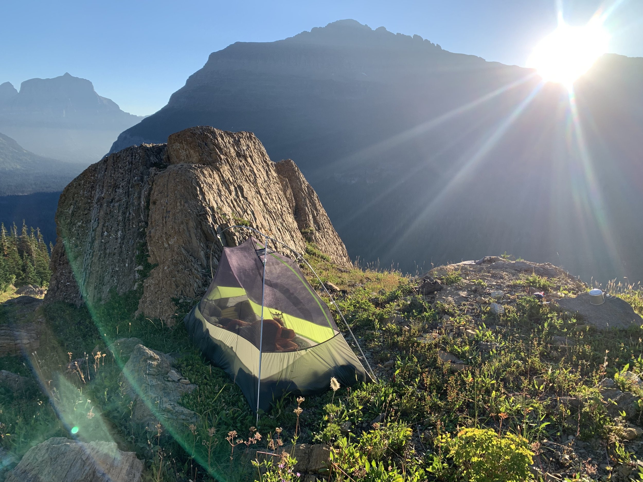
The hike had been a triumph, though surprisingly brutal and one of the hardest climbs I’d ever done… not because of its technical difficulty, but because I’d had to marshal every scrap of willpower I possessed just to keep my legs moving. Now I could finally crawl into my tent and let my mind slip into oblivion while my muscles began to rest and regenerate. And if a grizzly chose to snuggle up with me while I was sleeping, I doubted I would even notice.