Off The Map Side-Stories: #12: High and Dry
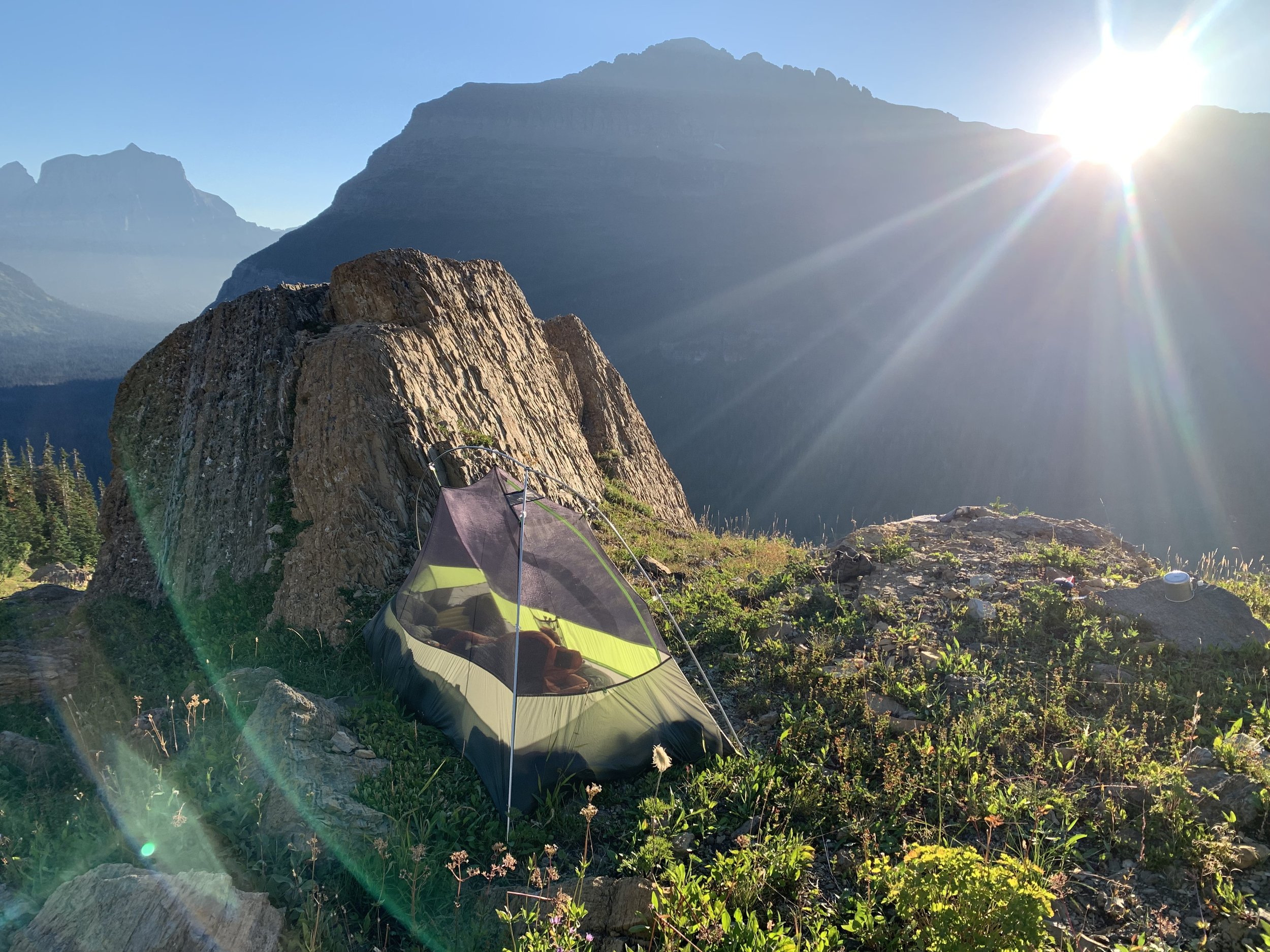
With the rising of the sun over the bulk of Citadel Mountain, I crawled from my cramped backpacker’s tent, stretched my stiffened muscles and began preparations for the climb up to 10,052-foot Mount Jackson – one of six peaks above ten thousand feet in the majestic expanse of ice-carved valleys within Montana’s Glacier National Park. The weather appeared to be holding, for there was not a cloud in the azure sky, just a thin wisp of smoke from some distant forest fire.
The first order of business was to pump some water. It was going to be a hot day, and I’d need both of my water bottles topped off if I was going to survive the four-thousand-foot climb in good health. I tromped over to the nearby stream, wondering why it sounded so unusually quiet when last night, the sound of water splashing from rock to rock was a soothing lullaby. The reason soon became shockingly apparent: it was completely dry.
I was stunned. Had a crevice opened up along the side of the mountain and drained the stream away? The most logical explanation was that the snowfields above my campsite had stopped melting overnight when the sun set and the temperature dropped. It was a predictable phenomenon, but I had never encountered such a stark difference in water flows before. There weren’t even any puddles to speak of. All the moisture had percolated through the pebbles and disappeared into the ground.
This unfortunate situation left me with a pair of unappealing options. I could hike two miles to Gunsight Lake and fill up there, then return and start the climb later in the morning. Or I could find a snowfield and cram ice crystals into my water bottles, hoping they’d melt into drinkable water along the way. I’d probably only end up with half as much water by the end of that process, though, and I wasn’t sure that would be enough for the journey.
I mulled over my choices back at my tent. Already the flies were waking up. I preferred them to mosquitoes, which had been more prevalent earlier in the summer, but the flies here were insidious in their unpredictability. They were mostly tiny and annoying, but one out of ten would suddenly decide to bite you, causing you to fling whatever you were holding - phone, food or walking stick - in a panicked effort to slap the bug away. Dithering over water wouldn’t do me any good, but I decided to pay the stream one last visit in case any pools remained along its length.
Finally, I found it – a depression in the rock itself that held a small quantity of water. The liquid was probably clean enough to drink without fear of bacteria, but using my filter pump helped me extract as many drops as possible from the narrow basin. It still wasn’t enough, but I hiked uphill and found another tiny puddle that barely sufficed to top off my bottles. Now I could begin the climb without fear of dehydration.
The first leg of the trek was a straight shot – two thousand feet upwards until I gained the north ridge. Nearby were the remnants of the Jackson Glacier, which had dwindled over the decades and was likely to vanish completely in another ten years. Some of the terrain showed signs of more recent glacial action; slabs of rock held scars from a colder climate, when a river of ice slid in slow-motion across their surfaces, dragging boulders along for the ride and scraping parallel lines that showed the direction of the glacier’s travel.
The elevation gain was relentless but made easier by the textured rock. I was literally walking on an ancient seabed made of sediments that had washed into the ocean over a billion years ago, back when the most advanced life forms on Earth were colonies of algae. The layers of sand and mud had compacted into rock, which was then thrust thousands of feet into the air to become the present-day Rocky Mountains. Elsewhere in Glacier National Park, I’d seen boulders that retained the ripples made by ocean currents that once sifted sand on the sea floor. Here on Mount Jackson, the mud had cracked into symmetrical patterns that were remarkably consistent, as if the rock had been designed by someone who made kitchen linoleum tile in the 1970s. The important thing was that my shoes gripped the slabs easily, making what could have been a slippery climb much safer.
Apart from a weasel I glimpsed bounding along the edge of a snowfield, I seemed to have the mountain to myself, for better or worse. Once I gained the north ridge and had a look at the remaining two thousand feet of elevation, I realized my solitary presence was definitely for the worse. The ridgeline was steep, narrow and grim, looming over me like the face of a growling tiger. I wasn’t sure how wise it would be to tackle the summit alone. If anything went wrong and I injured myself, crawling down to the campsites at Gunsight Lake wasn’t going to be an option.
I stowed away my hiking poles, as the terrain from here on out would require both hands and feet, and with great trepidation, I began scrambling. Cairns marked the most likely path, and I created my own piles of stacked rocks whenever I feared I might go astray while attempting to retrace my steps on the way down. Up close, the ridgeline appeared less threatening than it had appeared from a distance. At times, it offered more than one route, although I still had to be hyper-vigilant; a misplaced foot would have triggered an uncontrolled slide hundreds of feet down onto a remnant glacier to the west – a small glacier, to be sure, but with plenty of deep crevasses that would swallow up my broken body for good.
The mixture of anxiety and fun ended when I reached the Mount Jackson summit. At least, I thought it was the summit. The north ridgeline leveled off at the top, presenting me with a series of summits, several of which might contain the highest point. I thought I might be on the uppermost part of the ridge, but I couldn’t find the usual summit cairn, and several other bumps on the ridge looked potentially higher if I squinted my eyes and tilted my head. Thoroughly confused, I turned to a GPS app on my phone, which I had never done on previous trips. It was giving me a reading of 10,025 feet, which was about twenty-five feet shorter than it should have been, were I on the actual summit. My lateral placement seemed off as well.
I decided to take a break and spend a full hour absorbing the scenery. A thin haze of smoke permeated the landscape, lending a primordial feel to the succession of sharpened ridgelines. Along the northern horizon, a thicker band of brown smoke drifted toward the Canadian border. Hopefully, it would continue to migrate in that direction for the remainder of my trip. To the southwest, nestled beneath the western arm of Mount Jackson lay the Harrison Glacier – at last, a proper expanse of fissured ice that sloped down toward the southern valleys. After the rest of the glaciers in the park had melted away, which was expected over the next decade, this glacier could be the last one standing.
Before leaving Mount Jackson, I decided to venture over to the next highest point along the summit ridge, just in case it was, in fact, the real summit. In my absence, a trio of climbers gained the mountain peak, and I hung out with them for a while upon my return, swapping stories and taking staged photos. A fierce gust of wind blew the baseball cap from my head while I was having my picture taken. It tumbled down the cliffs to the north – a casualty, one could say, of my desire for documentation. Or my vanity.
My new friends relied on my guidance to help them navigate a better route down the mountain, and I was happy to assist them through the worst parts of the steep descent. Eventually, we parted ways, for I needed to return to my camp in the seldom-visited Zone Ten region of the park. A strong wind had arisen, keeping the flies at bay, but I worried that my fragile one-man backpacker’s tent would get buffeted too strongly overnight, making it hard to sleep. I chose to pack up and head to the forested shores of Gunsight Lake, where I’d at least have a windbreak if the breezes became too strong.
Along the way, I celebrated with a feast of blueberries. The bushes here had an abundance of fruit, and I couldn’t help but gorge myself, just as the bears had done before me. The prevalence of grizzlies in the area was readily apparent, based on the huge piles of scat that littered sections of the trail. From the metallic-blue coloration of the droppings, I could tell that the bears appreciated the blueberries as much as I did. Hopefully, they wouldn’t mind sharing.
I reached Gunsight Lake safely and went for a quick swim in the clear water. It was frigid, but not nearly as cold as I expected, considering how much of its water came from melted glaciers and snowbanks. I felt restored… enough to consider another climb the next day. Nothing as rugged or as high as Mount Jackson, but something worthy of the time it had taken to drive up to Glacier National Park from southern Montana.
Unfortunately, when I awoke the next morning, a brown cloud mass loomed over the northeastern sky. The winds must have shifted overnight, bringing the smoke of distant forest fires back south from Canada. By the time I had packed up my tent, it had drifted in front of the rising sun, creating an amber glow that grew more and more orange the closer I came to the trailhead. Temperatures dropped almost twenty degrees due to the thickness of the smoke, which was good in one sense, because Montana was experiencing a heat wave, but very bad for mountain views.
So instead of hurrying in order to attempt another climb late in the day, I took my time, stopping along the trail to pluck watery thimbleberries, chewy huckleberries, seed-filled raspberries and, of course, blueberries… blueberries most of all. It was a good reminder that not all of the treasures of Glacier National Park required one to climb four thousand feet to be able to appreciate them. Some were just an arm’s reach away.